
 Soon after we left Fairbanks we began to see more of the sun ! We travelled the Richardson Highway from Fairbanks to Delta Junction. We parked here to have a look at the Alaska Pipeline crossing the Tanana River; there is an interpretive sign about the pipeline.
|
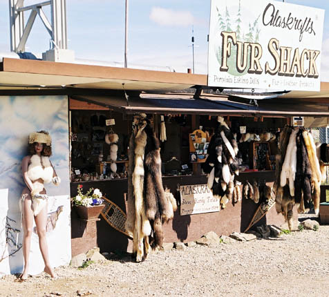
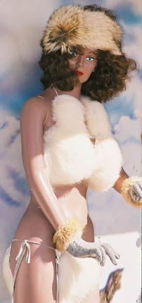 At the same spot, where the Alaska Pipeline crosses the Tanana River, one can find the "Fur Shack" and this mannequin displaying a fur bikini ! Apparently this is "the home of Ethel and her famous arctic fur bikini"... The fur shack sells fur and fur products, porcelain dolls and Alaskan clay ceramics. The bikinis come in Blue Fox, Lynx, Silver Fox, Wild Arctic Fox, Wolf (usd 350,-) and in Beaver, Coyote, Cross Fox, Red Fox (usd 250,-) But they have mittens, moccasins, pillows and blankets and other stuff too... Alaskrafts Fur Shack Alamo gave us an excellent deal on this Buick Regal, though it had some difficulties getting started in the mornings: it coughed, blew exhaust fumes in billowing clouds but then the onboard computer got things under control and it ran smoothly. |
 One cannot help but to be continuously on the lookout for wildlife...! Moose, bear, bald eagles... and many miles go by without seeing a trace of these animals. I have to admit we did little driving during the hours of dawn and dusk. But we did get to see wildlife ! A moose is seen while driving on the Alaska Highway, to Tok and it ignored us while it munched on the greenery, all the while being pestered by little flies and mosquitos. Awesome, to see it up close like this, it left us impressed when we continued our way.
|
Fairbanks was a "Gold Rush"-destination, but the search for gold went on in a much larger area that just Fairbanks. The "Pedro Dredge" operated at Chicken Creek during 1959-1967. The dredge is being restored to accommodate public tours. There is still mining going on in the area. The Pedro dredge, originally driven by steam, was built by the Yuba Manufacturing Company in California, and was shipped from Oakland on the S.S. Point San Pablo on April 1, 1938. It was assembled on Pedro Creek and began operating on July 11th. The Dredge operated on Pedro Creek, with the exception of the war years, until October 1958. Having completed its available ground there, it was decided to move it to Chicken Creek, as the Cowden Dredge, also belonging to the company, had suffered from years of neglect. It still rests in the Mosquito Fork of the Fortymile River.
The Pedro Dredge was owned by the Fairbanks Exploration Company (FE Co.), a subsidiary of the United States Smelting Refining & Mining Co. (USSR&M). It spent less than a third of its operating life on Chicken Creek. The 3-cubic-foot dredge (measurement of the bucket capacity), the smallest in the FE Co.'s dredge fleet, was originally built to mine the fairly shallow gravels of Pedro Creek, north of Fairbanks. The Pedro Dredge was disassembled on Pedro Creek and trucked to Chicken beginning in June 1959. The move and reconstruction were completed by September at a cost of $148,095. During the re-construction, the dredge was updated to diesel-electric, adding two Cat 375 engines for power. The dredge commenced operations on lower Chicken Creek in September and worked approximately five months every year thereafter until October 1967, when it produced its final cleanup. There were many hazards related to dredging in a northern riverbottom. In the spring of 1961, the Pedro Dredge was flooded by an early spring thaw that flooded the dredge pond before the dredge could be thawed loose from the still-frozen pond. Stuck in the ice, the dredge was unable to float on top of the flood as would normally happen. During its production years on Chicken Creek, the dredge washed about 2,500 cubic yards of gravel each day (29 buckets per minute) at a cost of around 30 cents per cubic yard. Between 0.30 and 0.80 ounces of gold were recovered from each cubic yard of gravel. There were normally 16-20 men employed in the operation, with 10-12 involved directly with the dredging and the remainder mostly associated with thawing ground ahead of the dredge. The dredge mined over 55,000 ounces of gold in the eight years on Chicken Creek. More on the Pedro Dredge |
At Milepost 86 is the old Jack Wade No. 1 dredge, it sits right alongside the highway. These mining dredges were used in Alaska and the Yukon from the turn-of-the-century on into the 1950s to extract gold from the land. For anyone interested in gold rush history and relics, the Taylor Highway is a great route because it has 3 dredges: the Pedro Dredge in Chicken; the Mosquito Fork Dredge, visible from the Mosquito Fork Dredge Hiking Trail; and this Jack Wade No.1 dredge. Later we'll see also Gold Dredge No. 4, which is located just outside Dawson City,YT.  These are huge vessels and they look amazing sitting like this in the shallow water of a tiny river; but of course one would build a creek by putting up a dam around it and let it float.
Leaving the Alaska Highway and going up Taylor Highway makes for a beautiful drive. From Tetlin Junction on the Alaska Highway, the Taylor Highway begins as a wide, paved highway. It also begins a gradual, winding climb to the summit of Mount Fairplay. It changes to a gravel road, but I found driving easy, provided one keeps the eyes on the road and speed consistent with the road conditions. |
 Is this adventurous or what ? The Taylor Highway and the Top of the World Highway must be high on the top 10 "most scenic routes"... The Taylor Highway, which starts 12 miles east of Tok, is a spectacularly scenic road that winds 160 miles to the village of Eagle on the banks of the Yukon River. We did not go as far as Eagle, as Dawson City in Canada was our destination today; so we headed for the Canadian border. This gravel road is closed in winter and services are limited. Travel is slow and one should be conservative in planning an "estimate time of arrival" anywhere. |
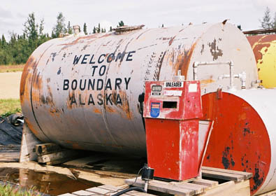
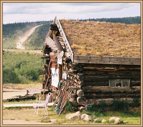
 Welcome to Boundary, Alaska ! Except for Chicken, this is the only place to stop for gas or some food. But it's an excellent place to bring the camera into action.. This is another place where you get that "Last Frontier"-feeling; must be real isolated in wintertime. |
 Like on our trip in 1995, we bought a copy of The Milepost, a constant source of information on places along the highways. It told to us that Boundary Lodge was one of the first roadhouses in Alaska.
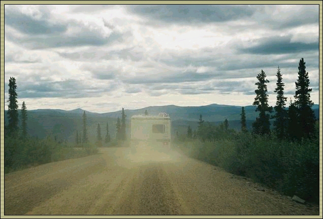
And look at that view: that was the road we came and I had to wait quite a while to see so many cars (I wanted to see the dust kicked up by those cars). From here it is only a few miles to the US-Canadian border. |
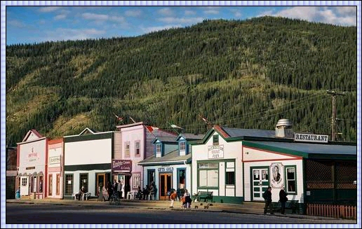
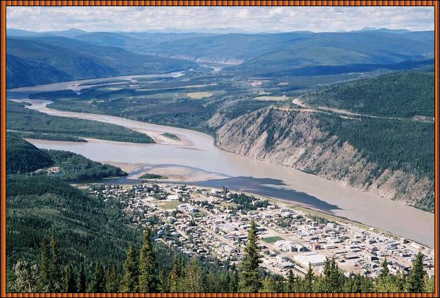 Dawson City ! Definitely one of the highlights of these holidays, it has a genuine feeling of a frontier town and while it caters for the tourists, it hasn't been turned into a Disney park. It certainly hasn't been discovered by the crowds, as its location is rather isolated. The road on the right side of the photo, is the road we came in on, over the mountains. It's closed in winters. One has to take the ferry across the Yukon River to get into town. From the left you can see the Klondike River coverging into the Yukon River. Along the Klondike River is the road to Whitehorse. Dawson City dates from the discovery of gold on a Klondike River tributary, Rabbit Creek (renamed Bonanza Creek) in 1896. It was originally laid out to serve 30.000 people and today Dawson City still occupies much of the original townsite but with only a fraction of the buildings and people. There is still goldmining going on. Famous is the "Trail of '98" when fortune seekers left in 1898 Seattle for Skagway by boat, fought ice and snow of the Chilkoot Pass or White Pass to Lake Lindeman and Bennett, found their way down to the Yukon River and then to Dawson City, to the GOLD !! |
 Dawson City townsite was prepared by Joe Ladue, a trader and sawmill operator, and surveyed by William Ogilvie. The town was named for George Mercer Dawson of the Geoligical Survey of Canada. Trading companies moved in from Forty Mile and Circle City and built warehouses along the waterfront. Goods were hauled into town by way of the Yukon River, but the river freezes up in wintertime. Sternwheelers plied the river for many years, but in 1953 a road was completed, linking Dawson with Whitehorse; this ended the need for a river route. Up until 1897 this place was a trading place for Indian trappers and about 200 white men. By 1900 Dawson City was the largest city west of Winnipeg and north of San Francisco.... By 1903, when new stampedes made people make their way to Nome and other Alaska points, the population levelled to more habitable numbers and Dawson City became a sturdy government-cum-mining town. |
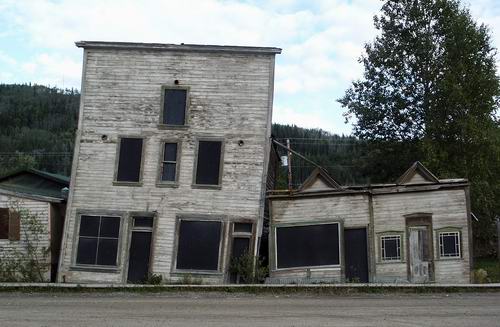 After World War 1 population declined and even reached levels where Dawson City almost became a ghost town. Each year a few more buildings were abandoned by owners. But they kept paying their taxes and thus kept ownership, maybe with dreams to return one day and find that fortune. Because the City Council was not allowed to touch them for repairs or protection, many of these abandoned houses have been destroyed by fire or vandals and others toppled by sheer neglect and the permafrost.
These structures were built in 1901 and they illustrate what can happen when heated buildings are placed on frozen ground; the frost melts, mixing water with the soil to form a very fluid muck into which the different footings settle at different rates. No restoration has been undertaken here, to illustrate this progress. |
|
In 1897, Jack London himself arrived in the Yukon as an aspiring prospector. After a few years of frustration, he turned his hand to writing and proceeded to entertain the world with tales of the Klondike such as �The Call of the Wild�. Today, the Jack London Cabin is maintained as an Interpretive Center. One book about the Klondike Gold Rush I enjoyed reading was "Klondike Women" (the True Tales of the 1897-1898 Gold Rush) by Melanie J. Mayer (Ohio University Pres, 1989). The writer quotes from many women who travelled to the Yukon for a wide variety of reasons and compiled it to a most readable and informative book. |
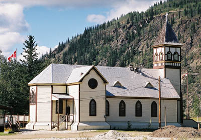
 Anglican Church (Episcopal) St Paul's (RIGHT) St.Andrew's Church and Manse was erected in 1901 and illustrates the properity and commitment of the congregation it served. It boasted a pipe organ and carved oak pews that could seat a crows of 600. The church bore the architectural stamp of the Gothic Revival popular elsewhere in the country. Together, with a spacious manse, of Second Empire design, it was one more element of familiarity and respectability in a city that was rapidly changing from its boom-town origins. |
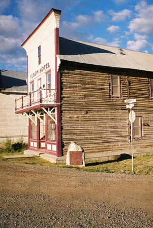
 The Yukon Hotel, and the stylish building on the right houses the museum, which one simply must visit; the latter also has the courtroom, where during our visit was an excellent photo exposition. Gold, discovered in 1896 on nearby creeks, caused the Klondike Gold Rush which turned this native summer fish camp at the junction of the Klondike and Yukon Rivers into the "Paris of the North". (The natives moved downstream to Moosehide.) That's not hard to believe if you look at that courthouse/museum. The money was good for some: by 1903, more than $96 million in gold had been taken out of the creeks. Ten years after the discovery of gold, the rush was over. There were a few millionaires and many who left with unfulfilled dreams; some gave up and others moved on. Today, tourism and gold mining are the major inductries here, both taking place during the summer months. Approximately 60,000 people visit Dawson City each year, but I hardly noticed any. Dawson City, history profile |
 The Klondike Dredge ("Historic Dredge No.4"), dinosaur of those bygone days. Impressive structures, huge.
 After the initial rush of 1898, gold mining in the Klondike settled down to an organized, corporate undertaking. This era, which extended up to the Second World War, was characterized by the use of gigantic floating dredges. Each dredge was a self-contained factory for processing the alluvial gravels that filled the valleys of the Klondike River, Bonanza Creek, and a few smaller areas. The dredge floated in a pond of its own making. Gravel was scooped in the front, extending the pond, processed to remove gold nuggets, then carried out the back on a long conveyor belt and dumped, filling in the pond behind. As it progressed the dredge swung slowly side-to-side, thus cutting a swathe wider than itself. Only 4 or 5 people were needed to operate the vessel but a hundred people or more were needed to prepare the area surrounding the dredging: cutting trees, melt the permafrost, move the vessel upstream, etc. The graveldigging by ths giant dredge produced an enormous racket, that could even be heard in Dawson City, miles away ! Workingcould cause loss of hearing, if one stayed long enough on this job. There is a very informative guided tour conducted here. More on the Klondike Stampede of 1898 |
|
These large gold dredges were built in the 1920's and 1930's by large mining companies to work the countless acres of gravel and streambeds that held gold. Some survived as we have seen on the previous photos, they are usually abandoned and some are guarded by private land or sheer inaccessibility. Parts of the old dredges, notably the giant digging buckets, end up in strange places such as planters and lawn ornaments. |
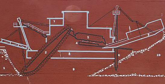 | 1. Gold Bearin Gravel 2. Bucket Excavator 3. Revolving Screen 4. Gold Saving Sluice 5. Tailings Stacker 6. Dredge Pivot Point 7. Master Control Room 8. Floating Barge 9. Self-Dug Dredge Pond 10. Tailing (washed gravel) |
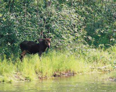 Taking the North Klondike Highway, only a few miles outside Dawson City, we caught a fleeting glimpse of a young moose; by the time we stopped the car I had
only a moment to shoot this picture before it fled in the thick bushes to join the rest of the family.
Taking the North Klondike Highway, only a few miles outside Dawson City, we caught a fleeting glimpse of a young moose; by the time we stopped the car I had
only a moment to shoot this picture before it fled in the thick bushes to join the rest of the family.Later on the trip we also saw bear, twice, but I was unable to catch them on film. |
 It is quite a drive to Whitehorse, so the stop and hike to "Five Fingers" was very welcome. Ever since leaving Fairbanks we had fine weather and even the mosquitos left us alone on the one hour hike.
Whitehorse, the capital of the Yukon Territory, received its name from the nearby rapids of the Yukon River where the frothing water looked like the manes of white horses. The name has been used since 1887. |
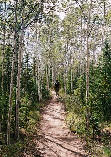 I am forever in constant conflict: I want to see as much as I can and compile an itinerary that seems to keep me too much in my car, driving large distances (this time 2200 miles -3500 kms- in 3 weeks), only to find myself wishing I had more time to hike trails... I am forever in constant conflict: I want to see as much as I can and compile an itinerary that seems to keep me too much in my car, driving large distances (this time 2200 miles -3500 kms- in 3 weeks), only to find myself wishing I had more time to hike trails...But this one was nice, though it wasn't much of a hike, more something like "stretching the legs". The 219 steps to take us down to the level of the woods were the most strenuous and the wooded area was varied, quiet, an easy walk. It brought us up close to the "Five Fingers", though the rapids are now pacified by taking one obstacle away, no roaring white water anymore. |
 We found that the owners were from Switzerland, having people over from Germany. Guests at another table were someone from Switzerland or Germany with his Spanish girlfriend. No one else, except us. With our Dutch nationalities that was quite a United Nations there ! It advertises as one of the best-known roadhouses in the North, the lodge is located between Whitehorse and Dawson City, 368.7 kilometers (229.1 miles) north of the junction with the Alaska Highway. |

 Whenever I get the chance, I have to take pictures such as these... |
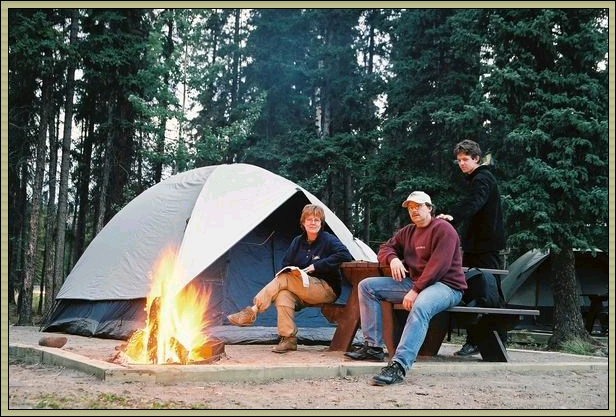 Our campsite at the Robert Service Campground at Whitehorse, with an excellent campfire going. Is that an axe Alexander is waving behind me....?
We did not camp as much as we had planned, also because of the rain we had initially, but it's worth to drag the extra gear around and spend some time in the open. And after a few nights it is extra pleasant to enjoy the luxury of a bed and chill out in front of the telly in a motel !! Make sure you visit The Yukon Transportation Museum, located at Historic Mile 917 (km 1475.7) Alaska Highway - by the Whitehorse Airport. |

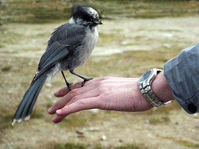 Leaving Whitehorse for Skagway, we stopped before getting to White Pass and witnessed some railway maintenance cars stopping by. Funny little things. At the same place these birds (Canada Gray Jay - Perisoreus canadensis) were quite comfortable with people around. It's a rather desolate country, passing Lake Bennett, and we headed for the mountains. |
White Pass ! On the border of Canada and US (Alaska) we traversed this huge barrier in weather which illustrated something of the atmosphere how it must have felt travelling on foot in rain and snow... There is a railwayline that is very popular with the tourists and which was an enormous improvement for people early in the 1900s.
The discovery of gold in the Klondike ignited one of the most remarkable stampedes of people in history. But how to get to those goldfields ? People suffered unbelievable hardships and hundreds of companies were formed to get people there by ship, wagon, horse, dogsled, railroad and even by balloon! The White Pass & Yukon Route (WP&YR) narrow gauge railroad is the only one of those companies which still survives to this day. This railroad through the granite of the Coastal Mountains was almost beyond men's capacities of those days. Construction on the 112-mile line to Whitehorse,YT began on May 27, 1898 in Skagway,AK. Just over 2 years later, on July 29, 1900, the final spike was driven at Carcross. |
 We drove over White Pass and there wasn't time to enjoy the railroad, maybe another time, but nature's inhospitality was all around us and the harsh weather conditions that reign here (the pass get blocked by snow during wintertime and spring's opening of the pass is a bit of a milestone every year) were only too evident. We drove over White Pass and there wasn't time to enjoy the railroad, maybe another time, but nature's inhospitality was all around us and the harsh weather conditions that reign here (the pass get blocked by snow during wintertime and spring's opening of the pass is a bit of a milestone every year) were only too evident. |
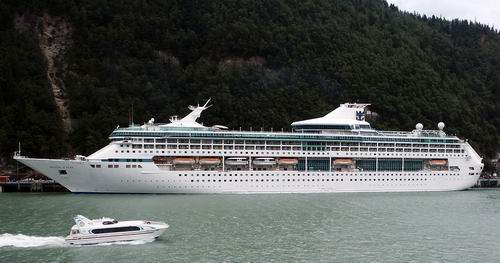
 The name Skagway was originally spelled Skaguay and is said to mean 'home of the north wind' in the local Tlingit dialect. It is often called the �Gateway to the Klondike� lies at the most northern tip of the Inside Passage in Southeastern Alaska, the protected waterway stretching for more than 1000 miles along. As fast as it had begun, the mad rush dwindled. By the summer of 1899 the stampede was all but over. Skagway�s population dwindled just as quickly to 500. But Skagway held on as a port and the terminus of White Pass and Yukon railway, connecting the Inside Passage to Whitehorse, Yukon Territory. Cruise ships bring tourism and business to Skagway. The Alaska Marine Highway System began scheduled state ferry service in 1963. Since we felt Skagway was more spoiled by tourism than Dawson City, we took the opportunity to take the ferry to Haines and left a more thorough visit to Skagway for another day. |
 We found a vey nice motel in Haines: Captain's Choice. We overlooked the way we came in. A strange ferry by the way: the restaurants closed upon sailing and during the voyage... But not expensive, only usd 91,- for the car and the three of us. We found a vey nice motel in Haines: Captain's Choice. We overlooked the way we came in. A strange ferry by the way: the restaurants closed upon sailing and during the voyage... But not expensive, only usd 91,- for the car and the three of us.No sightings of any whales during the one hour crossing, nor from our motelroom, unfortunately. Wouldn't that have been fantastice ? We had been speaking to someone at Tok who said she had seen whales during this ferry crossing, so it seems possible. |
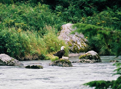 We asked around for a place where one might have an opportunity to see bears... We were directed to a river which connects Chilkoot Lake to the Lutak Inlet, but no bears were seen. We asked around for a place where one might have an opportunity to see bears... We were directed to a river which connects Chilkoot Lake to the Lutak Inlet, but no bears were seen.We did see a bald eagle catching a fish and later another bald eagle joined the fun. We held our breath in respect for these magnificent birds. The Chilkat Valley is a safe haven for bald eagles, they gather here during fall and winter; they are drawn by the warm open water and the plentiful supply of salmon. Several hundreds call it their home here, but numbers grow to almost 3500 in november, the largest gathering of eagles in the world. |
Haines Highway Summit, elevation 1070 m. Perhaps the most beautiful road I have ever driven.... Again, the road is almost deserted, the pass brings showers which you see coming towards you and pass in matter of minutes. You could see for miles, the towering mountain peaks of the St.Elias Mountains leave a lasting impression and every now and then a glacier shows a little bit of itself. 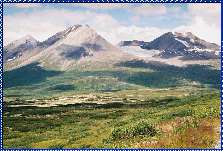 As long ago as 1882 one Arthur Krause of the Bremen Geographical Society explored this route. In the early 1890's, Jack Dalton, an adventurer and entrepreneur of controversial repute improved on a trail system from Pyramid Harbor, Alaska, on the Chilkat Inlet to the confluence of the Nordendskiold and Lewis (Yukon) Rivers well within the Yukon. This trail, developed well before the Klondike gold strike, consisted primarily of existing Indian trails. From 1897 to 1899 hoards of optimistic gold seekers used the then well- beaten trail on their trek north. Locally, in the summer of 1898, placer gold was discovered on Porcupine Creek, Alaska. By 1899, a wagon road extended from Pyramid Harbor via Porcupine, along the south side of the Klehini to Pleasant Camp. In the post war era the Haines Road served well as an extension of the Alaska Marine Highway System to northern Alaska. It first opened on a year- round basis in 1963. Considering the severity of winter storms, maintenance of the highway was and still is a challenge by any mans measure. The Haines "Cut-Off" Road, approximately 160 miles of spectacular beauty, connects the Alaskan seaport of Haines with the Alaska Highway at Haines Junction, our destination for the day. Haines Highway |
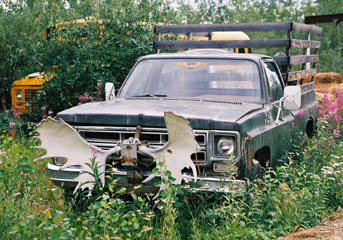
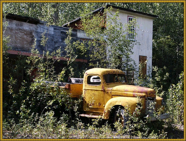 A deserted, overgrown house and an abondoned truck: time to get out of the car and activate the shutter ! |
 Ah well, this is a bit of a story... I had heard of a wreck in the Ruby Mountains. Not just a wreck, but one virtually intact and a Douglas DC-3 (a vintage transport in which I have a historical interest). I had hoped to hire a helicopter, but hadn't booked it because of some uncertainties in my itinerary. Unfortunately, the chopper wasn't available as it was rented by mining inspectors for most of the day. I thought I had to abandon my plan... Ah well, this is a bit of a story... I had heard of a wreck in the Ruby Mountains. Not just a wreck, but one virtually intact and a Douglas DC-3 (a vintage transport in which I have a historical interest). I had hoped to hire a helicopter, but hadn't booked it because of some uncertainties in my itinerary. Unfortunately, the chopper wasn't available as it was rented by mining inspectors for most of the day. I thought I had to abandon my plan...At Haines Junction airfield was a company called Sifton Air, they do flightseeing flights to the glaciers of the Kluane Mountains. But I wanted to go the other way. It was a bit like looking for the proverbial needle in the haystack, but our pilot Kate (over for a few months from New Zealand) managed to find it based on the instructions of her boss. |
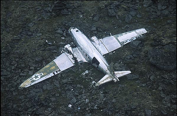 And there it is !
Taking pictures wasn't very easy as the circling approach gave me only a second or two to snap the shutter. Fortunately the weather was good and we circled about 7 or 8 times, quite a different "flightseeing flight" than one would normally undertake. And there it is !
Taking pictures wasn't very easy as the circling approach gave me only a second or two to snap the shutter. Fortunately the weather was good and we circled about 7 or 8 times, quite a different "flightseeing flight" than one would normally undertake.On January 26, 1950 a U.S. air force C-54 transport plane en route from Elmendorf AFB in Anchorage to Great Falls AFB in Montana vanished somewhere near Whitehorse. There were 33 military personnel, eight crew and three civilians. To this day this aircraft has never been found. This Douglas DC-3 (actually, the military variant is called the C-47) partcipated in the search and fell victim itself as it found itself unable to clear the mountain and it crashlanded in the snow. The pilot walked (!) 13 km out to the Alaska Highway (that in itself is a miracle!) in extreme terrain, was picked up by a transport truck and driven to Whitehorse. He led a search party back to the scene and all were rescued. More on the Mystery C-47 in the Yukon From Haines Junction we drove to Tok, completing the Klondike Loop. |
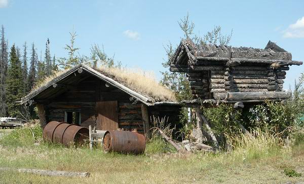 From Tok we drove to Glennallen and onwards to Palmer; it was a long drive with quite a bit of delay by road construction again. This old sod cabin and the "cache" (elevated to keep it from flooding and prowling animals) was photographed along the Glenn Highway, probably around Glennallen but I am not sure.
 |
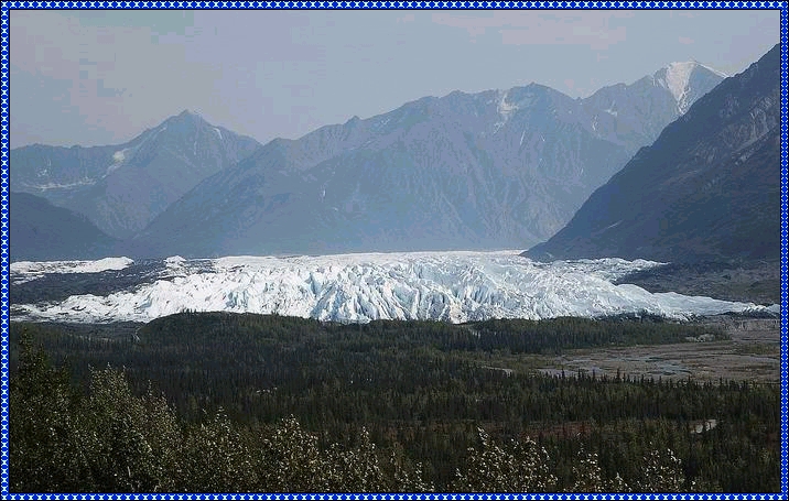 Matanuska Glacier is a beautiful valley glacier 24 miles long and four miles wide, decending twelve thousand feet to the terminus and is on the Glenn Highway. Unfortunately, extensive roadworks did not allow us to park but we had to keep going until we reached a parking at the end of the roadconstruction, only therecould we park and enjoy one final glance at this impressive glacier. The roadconstruction allowed for one more surprise: when we were ready to leave our motel in Palmer, we found we had a flat tyre... But the remaining day was uneventful, bought some more books at Title Wave, had an excellent flight with Alaska Airlines to Seattle and British Airways extended the courtesy to upgrade us to Business Class on our trip home, which was really icing on the cake, a perfect conclusion to a unique holiday! |
 Click on the Alaska flag to return to Part 1: Anchorage and Fairbanks |
|
 In 1953 the government moved from Dawson City to Whitehorse, which is better situated on the railway and highway and has a large airport. Dawson City was declareda national historic site in the early 1960s. Parks Canada is involved in many properties here in Dawson City, many buildings will be restored, some reconstructed and others stabilized.
